| Finished City-Climate-Projects |
|
| Information
System Urban and Environment Berlin (1990-2005) Most recent product of the team of ISU to the topic city-climate is the publication
of the results of the two phases, i.e. I - analysis - and II - evaluation – of
the application of the regional climate-model FITNAH for Berlin and
its surroundings. An exact description of the model is available at
Richter & Röckle o.J..
With the online-going in September 2004, the results of the most
extensive examination of the city climate of Berlin on the basis
of an digital
model are disposible. Especially the representations and planning evaluations
to the near ground air-exchange-systems as they can appear between
different land uses, offer for the first time – unlike to the statements
of the already existing climate-maps of the environmental atlas - quantifiable
data to the capability of the urban climate-household and can be used
as valuable planning-advices (under observation of the boundary conditions
of the examination). Through the inclusion of an examination-area of
approximately 1 500 km˛, from which the city of Berlin captures approximately
900 km˛, also the Berlin-Brandenburg-relationships in this connections
are considered. The transposition into area-specific climate- and
immission-ecological quality-goals result in the formulation of behaviour
guidelines. With the concrete assignment of planning-relevant statements
to the important structure elements, which are responsible for climate-ecological
processes like cold air formation surfaces, cold air stream channels
and bio-climatical comfort areas, one can secure on the one hand their
continuance and protection from negative influences. On the other
hand, burden-areas are identified with a lack of air exchange and/or
possible air-hygienic pollution caused by traffic-immissions. These
methodical procedures allow well-founded statements for the scale of
1: 100 000 to 1: 20 000. A first appraising judgment of the effects
of planning-measures is however also given up to the level of the development-plans. Information to all projects given by: Methods: climate measuring truck, measuring-sites and
-trips, Landsat TM-scenes, interpolation programs, GIS-embadding,
climate-models like UBIKLIM, MUKLIMO, FITNAH, furthermore wind-canal-examinations
and spread-calculations for air pollutants. Digital Environmental Atlas: All published informations(texts, graphics, tables and maps)are available free of charge in different formats
(MS-Word6, MS-Excel, pdf-data files, gif-files)
Environmental Atlas Berlin .
New Air Pollution Control and
Action Plan 2005-2010
Short Description
Air-quality in Berlin is controlled at more than 20 measurement-stations of the Berlin air control measurement
system BLUME through mostly continuous measurements for sulphur dioxide, nitrogen dioxide, carbonic-monoxide, benzene, ozone, fine-dust
PM10 and carbon-black. The automatic data-transfer to the control center allows a hourly representation of the current
measurements in the internet.
The evaluation of the quality of the Berlin air is geared to the
limits and standard values of the ordinances and administration-rules
of the Federal-Immission-Protective Law and to the guidelines
of the European
Union.
Measurements alone are not enough in order to clean the Berlin air.
Finally, it depends on the diminution of the pollutant-output from
traffic, industrial plants, power plants and from private households.
Data, collected from the pollutants discharged in Berlin (the emissions),
are compared with the data from measurements of the air pollution
(the immission) to get a well-founded basis for a cause analysis of the
air-burden
in the city. The table below
contains a summarizing judgment of the air-quality in Berlin. The
new EC-limits are the basis for the evaluations.
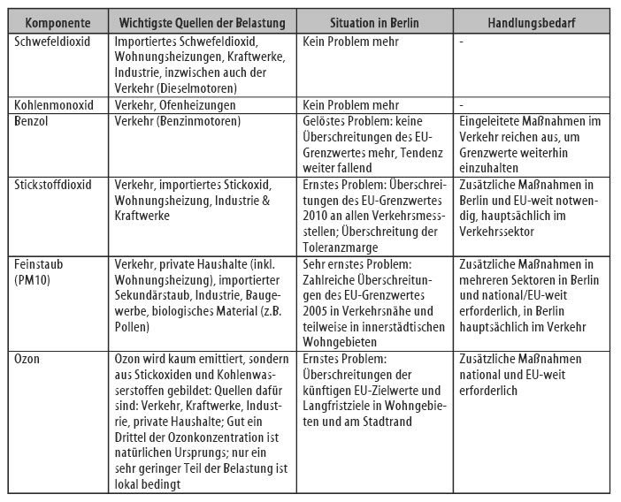
It appears that sulphur dioxide and carbonic-monoxide falled below the
air-quality-goals about a multiple. Also the benzene-burden in the Berlin
main road-network has sunk to one fourth of the values at the beginning
of the 90th years,
so that since 2003 the values fall below the benzene-limit value of 2010
in all main streets. Nitrogen dioxide, fine-dust (PM10) and ozone remain as problems of the air-cleaning policy. Especially, measures to
the observance of the nitrogen dioxide - and PM10-thresholds are also in the responsibility of the state of Berlin. So the main focus for the air pollution control in Berlin concentrates on the abatement of the air-burden through
fine-dust and nitrogen dioxide. In order to be able to evaluate the demand of additional measures to decrease the emissions,
the development of the burden of airborne-particle and nitrogen oxides until 2010 was estimated. Nevertheless the compliance with the number of the 24h critical-limit
for fine-dust and the annual average value for nitrogen dioxide will be
a problem. Here,
the strategy is focused mainly on the essential Berlin source-group, the
traffic, even taking into account that the emissions of private cars and
trucks were definitely reduced in the last years. Beside numerous other measures, as they are described decidedly in the
air pollution control plan, the future strategy also includes–with granting
of an appropriate period and on condition of standard regulations - limitations
for strongly emitting diesel-motorcars
for the Berlin city area. The following two-level action-plan is
decided, so called the
„level-concept for the Berlin environment-zone": Step 1 from 2008: In the Berlin city area, diesel-motorcars have to achieve at least the pollutant-degree Euro II. Step 2 from 2010: In the Berlin city area, diesel-motorcars have to achieve
at least the pollutant-degree Euro II and have to use a carbon-particulate
filter. If there will be a general availability of carbon-particulate filters until 2008, it’s possible
that additionaly in step 1 beside the minimum-criterion of the Euro-Norm II, cars have to be backfitted
with those filters. With the help of this level-concept it will be potentiated to disburden at least 10.000
concerned residents in the city-area up to the year 2010 . Additionally to technical measures at cars and power plants etc. the framework of the
city-development
plan “Traffic” has developed a politics of traffic-avoidance and shifting of traffic. This should reduce not
only the exhaust fumes but contributes also to the sorely necessary noise reduction. Information given: Methods: Literature: Human-biometeorological Evaluation of Berlin Short Description Information to all projects given by: German federal meterological service,
service human biometeorology,
Ms. A. Grätz, Stefan-Meier-Str. 4, D-79104 Freiburg, phone: (++49)
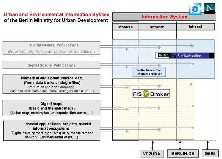
761 282020, fax: (++49) 761 282090. Additional activities related to these themes: Methods: GIS, climate-model UBIKLIM, mathematical algorithms. Digital Environmental Atlas: All published informations (texts, graphics, tables and maps) are available free of charge in different formats (MS-Word6, MS-Excel, pdf-data files, gif-files) Environmental Atlas BerlinFIS-Broker Über den FIS-Broker: Moreover with the FIS-Broker the Urban and Environmental Information system complies with the Free environmental information act of the European Union and the Convention on access to environmental information and public participation of the UN ECE (Ĺrhus convention). The aim is to describe, search, find, select, visualise and to provide data of heterogeneous origins and structure, using standard DP tools, and thereby enabling every user to work with the broker without specific DP knowledge. There are several digitally processed publications of the Ministry in the Internet and the Intranet (Internal Network of the Berlin Public Administration). Moreover a huge amount of digital information already exists, which has, until now, been barely accessible. These will be made available for use and research through an easy handling uniform browser-tool in the FIS-Broker. A core tool of the FIS-Broker will be theMeta information system in order to describe, search and find the different information. The specific GIS and data bank adapter will allow heterogeneous Geodata (from different GIS systems, different coordinate systems and scales, different spatial references) as well as heterogeneous numerical and alphanumerical data (from different data bank systems, with different spatial references) to be presented. The spatial relation service will allow for the combining of databases with different spatial references, thereby providing for a new range of data possibilities. A download function will provide for the further processing of the selected data bases as a whole or in parts through desktop tools (Excel, Access, GIS). A data-publishing tool will assist the owner of the new data sets to integrate them into the system and to describe them according to the requirements of a Meta information system. The original data can be left unchanged. Access will be via the broker. The above-described components of the FIS-Broker can be used directly in any module of the entire special information systems.
|